New Jersey Future Blog
Stormwater Pays No Mind to Municipal Borders—Why Should You?
July 17th, 2024 by Chris Sotiro
“Stormwater follows watershed boundaries, not political boundaries,” said Dr. Dan Van Abs, Professor at Rutgers University, during the 2024 New Jersey Planning & Redevelopment Conference (PRC). Many of New Jersey’s 564 municipalities grapple with flooding issues. For some, it is not uncommon for as little as three inches of rainfall to grind daily life to a halt. As average precipitation and severe weather events increase due to climate change, New Jersey will experience more frequent flooding. As the most densely populated and most developed state in the country, our flooding woes are amplified by the propensity for stormwater runoff to pollute sources of drinking water. In order to prevent chronic flooding and water quality impairments, municipalities must cooperate on a regional scale to improve their shared watersheds.
A panel of experts in the stormwater and watershed management spaces explored the benefits of a regional approach to watershed planning at the 2024 NJPRC, sponsored by New Jersey Future and the New Jersey chapter of the American Planning Association. The session “Save Money, Talk to Your Neighbors: The Case for Regional Watershed-Based Planning” featured Dan Van Abs, Professor of Professional Practice at Rutgers University, Jim Cosgrove, President of One Water Consulting, Lindsey Sigmund, Program Manager at New Jersey Future, Mike Pisauro, Policy Director at The Watershed Institute, Nicole Miller, Principal of MnM Consulting, and Tom Dallessio, Executive Director of the Musconetcong Watershed Association.


New Jersey’s Watershed Management Areas (WMAs)
As Mike Pisauro of The Watershed Institute explained, a major component of the new Municipal Separate Storm Sewer System (MS4) Permits—applicable to every municipality across the state—is the development of a Watershed Improvement Plan (WIP). While it is important to identify avenues for reducing water quality impairments, municipalities are limited in their ability to holistically address the watershed they occupy. Whereas a municipality can be affected by poor watershed management upstream, it cannot enforce improvement projects outside of its own local borders.
Some municipalities have simply been dealt a bad hand of cards, like Manville Borough, which sits at the bottom of the North and South Branch of the Raritan River. During Hurricane Ida ten inches of rain over a three-hour period led to a record-high 27.66-foot crest of the Raritan River, leaving some residents to experience flood waters reaching the second floor of their homes. “Manville can do the greatest job in the world with its Watershed Improvement Plan, but if they don’t incorporate what is going on upstream, there is no way they will solve flooding,” according to James Cosgrove of One Water Consulting. It is an unfortunate reality that the inaction of upstream communities often sets the stage for water quality impairments that are felt by downstream residents. Absent strong regional cooperation between municipalities throughout the entirety of the North and South Branch Raritan Watershed Management Area to take measures to capture and store excess stormwater, Manville will be on its own.

President Joe Biden tours a neighborhood in Manville Borough and talks with residents affected by the flooding caused by Hurricane Ida
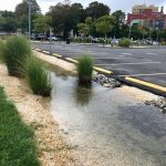
Operating as 564 separate systems is both tedious and redundant when it comes to watershed planning. While some municipalities may not deal with severe flooding as frequently as others, all towns, and the state, benefit from a healthy watershed. Simple river restoration actions, like tree plantings, streambank support, and water quality testing can ensure that freshwater drinking water sources are protected from non-point source pollutants. Low-cost green infrastructure projects capture, store, and filter excess stormwater to prevent it from overwhelming roads and waterways.
The Watershed Improvement Plan (WIP) for each municipality entails three phases: a Watershed Inventory Report, a Watershed Assessment Report, and a final WIP Report. While each municipality must complete its own WIP, there are opportunities for collaboration throughout its multi-year development process. For example, municipalities can work together to complete outfall drainage area mapping, which often spans across local borders and may require assistance from external consultants. Also, holding public information sessions to relay findings from Watershed Assessment Reports would be incredibly more efficient if convened on a regional basis, in contrast to independent meetings with residents. An open dialogue is vital to the watershed improvement planning process. “We want to engage community representatives early in the process. Across the state, advocates are working on these exact kinds of solutions, and they may have the solutions already in play, but simply need to be connected with one another to create effective change,” according to Nicole Miller of MnM Consulting.
Regional collaboration has the capacity to effectively and efficiently improve flooding and water quality, foster relationships between municipalities, save time, and save costs for all parties involved. Local watershed associations are well-poised to facilitate regional conversations, as they are well-established groups that routinely work with municipal officials. Municipalities may lack the tools or expertise for regional watershed-based planning on their own, but as Tom Dallessio of the Musconetcong Watershed Association explains, “Our job as a watershed association is to work with communities to improve water quality… You can’t address issues like water quality without a plan in place.” As municipalities work to draft their Watershed Improvement Plans under the new MS4 Permits, they must pursue every opportunity to work across municipal borders and with local watershed organizations to pool resources and share knowledge to build a more resilient watershed in the face of exacerbated flooding and water quality impairments under climate change.
Related Posts
 January 4, 2023 New NJDEP Watershed Improvement Plan Requirement and What This Means for Municipalities
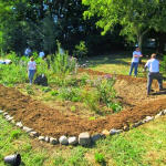 September 20, 2023 Green Infrastructure in the Garden State: Stormwater Research in the Delaware River Watershed
 July 17, 2023 Planning for Climate Resilient Stormwater Infrastructure
 July 8, 2022 Reducing Rain’s Repercussions: Exploring the Potential for Green Infrastructure on Redevelopment Sites
 June 24, 2022 Making Savvy, Successful Stormwater Solutions: Why the Municipal Separate Storm Sewer (MS4) Permit Renewal Matters
Tags: 2024 NJ Planning and Redevelopment Conference, green infrastructure, MS4, regional planning, Stormwater, stormwater management, Watershed, watershed improvement plan


