New Jersey Future Blog
Population Trends at the Jersey Shore, Part 2: The Sandy Effect
November 1st, 2016 by Tim Evans
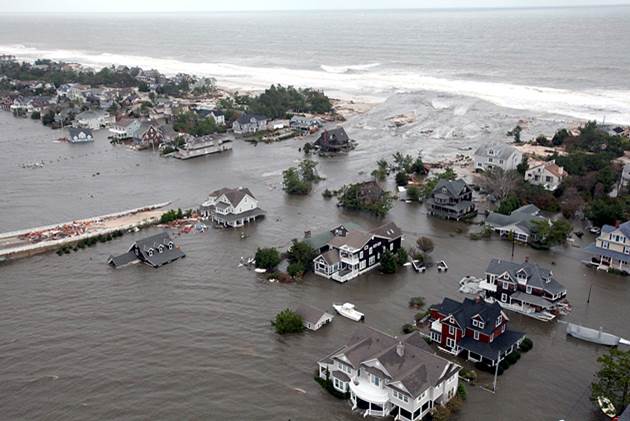
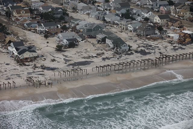
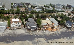 Four years ago Hurricane Sandy devastated our region, raising new questions about the vulnerability of our coastal communities and what the future might hold for businesses and residents at the Shore. In this second of two articles, New Jersey Future intern Sarah Koenig looks at population and housing trends since October of 2012, using the 2012 and 2014 (the most recent available) versions of the American Community Survey to approximate the post-Sandy period. (Part 1 of the findings addressed longer-term trends revealed in the data that pre-date Sandy.)
As described in Part 1, we defined “the Shore” as the set of all municipalities that fall wholly or partially within the jurisdiction of the Coastal Area Facilities Review Act (CAFRA) and then further assigned each of these municipalities to one of three locational groups, based on which body of water it primarily borders: 1) Atlantic oceanfront; 2) bays and other coastal areas; and 3) non-coastal but tidal riverine areas.
Data for the post-Sandy period, however, make clear that the storm was a hydrological event that did not make cultural or real-estate distinctions. Between 2012 and 2014, the bays/other coastal and riverine CAFRA subgroups behaved more similarly to the Atlantic oceanfront municipalities than they had prior to Sandy. And all three CAFRA subgroups diverged from statewide trends in important ways:
- Population continued to decline along the Atlantic oceanfront. Year-round population declined by a tenth of a percent between 2012 and 2014 in the Atlantic oceanfront subgroup; the other CAFRA subgroups and the rest of the state all increased in population in this same period. But this was actually the continuation of a longer-term trend; the Atlantic oceanfront municipalities as a group had also been losing population from 2000 to 2012, unlike the other CAFRA subgroups or the state as a whole.
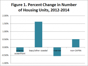 The number of housing units near water decreased. The total number of housing units decreased by about 950 in the Atlantic oceanfront subgroup. There was also a decrease of about 950 units in the riverine subgroup, possibly also reflecting Sandy damage from flooding farther inland. The total number of housing units in the “other coastal” subgroup increased, however, and at higher than the statewide rate (see Figure 1), though some of the larger municipal-level increases were in geographically large municipalities like Old Bridge Township, Sayreville Borough, and Galloway Township, in which most of the land is not on the coast and where enough housing units may have been added in non-coastal areas to more than counterbalance any units that may have been destroyed in coastal areas. A sub-municipal analysis would be required to see if the coastal parts of these municipalities have fared worse than the inland parts; the large geographic size of some of the “other coastal” municipalities may be causing the municipal-level data to mask internal disparities between their CAFRA and non-CAFRA sections. (This can also be true of the riverine subgroup, many of which towns are also comparatively large.)
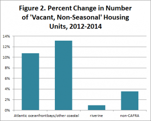 More coastal houses were vacant year-round. The number of housing units that were full-time vacant (as opposed to seasonal vacation or rental properties that are vacant for only part of the year) increased by 10.8 percent in the Atlantic oceanfront subgroup and by 13.2 percent in the “other coastal” subgroup, compared to much smaller increases of 0.9 percent in the riverine group and 3.6 percent in the rest of the state. This could be an indication of damage from Sandy that was extensive enough in these areas that some year-round residents hadn’t returned to their homes as of 2014. (See Figure 2.)
- The number of “coastal” (but not oceanfront) vacation properties increased. In the “other coastal” category, there was a notable uptick in the number and percent of housing units that are only seasonally occupied (i.e., vacation properties). The number of such properties increased by 6.3 percent between 2012 and 2014, in contrast to negligible changes in the other two CAFRA subgroups. One possibility is that properties bordering bodies of water other than the Atlantic Ocean, or properties that are within driving distance of the ocean but not walking distance, are becoming more attractive as vacation homes or seasonal rentals, in light of the more severe damage inflicted by Sandy on properties directly exposed to the ocean. This would take a sub-municipal analysis to verify.
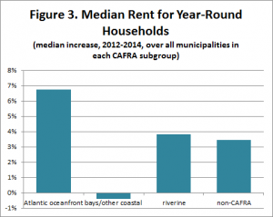 Oceanfront rents shot up. Median rents in the Atlantic oceanfront towns, which had typically been slightly lower than the statewide average prior to 2012, rose significantly faster after Hurricane Sandy than they did in the state overall. (See Figure 3.) Among the 46 municipalities in the Atlantic oceanfront subgroup, the median increase in median rent was 6.75 percent, compared to a median increase of 3.47 percent for non-CAFRA municipalities. (The median increase among the 35 municipalities in the riverine subgroup mirrored that of the state at 3.84 percent, while the median change among the 40 “other coastal” municipalities was actually a small decrease of 0.4 percent.) This may speak to a post-Sandy shortage of available rental housing for permanent residents in the Atlantic oceanfront. (Median rents are compiled only for year-round residences; the ACS does not collect data on seasonal rentals.)
More Questions Than Answers
Overall, it’s difficult to draw definitive conclusions about post-Sandy conditions from data that span only two years; the picture will undoubtedly become clearer when five years’ worth of data become available. However, anecdotal evidence suggests strongly that the year-round, modest-income households that typified many coastal communities are being replaced by higher-income vacation-home owners. Many prior residents have still not returned home and many may never be able to afford to return. Conversations with local building officials indicate that many new units along the coast that are replacing Sandy-damaged units are of significantly higher value than their predecessors.
If these changes persist, they raise several important questions about how the social, civic and economic fabric that has characterized the shore for generations might change:
- If indeed we are witnessing a de facto “retreat” from the Shore, with the number of people who live year-round on the oceanfront declining, and if their full-time residences are being replaced by seasonal properties, might this actually be a desirable outcome, given the expectation that the combination of sea level rise and stronger and more frequent storms are likely to make the Shore an increasingly hazardous place to make one’s permanent home?
- What are the equity ramifications if displaced residents of modest means are supplanted by wealthier property owners who are building larger second homes? Should only those who can afford it be able to build in such vulnerable areas and have the rest of the state subsidize the services and infrastructure necessary to serve these places?
- As the number of year-round residents in these communities continues to decline, is there a point at which municipalities will consider merging or dissolving to prevent the decreasing number of full-time residents from having to shoulder an ever increasing tax burden?
- Can we take lessons learned from other regional planning entities that recognize the cultural, recreational, environmental and tourism assets that exist, like the Meadowlands, Highlands or Pinelands, and create a “Shore” region with the power to plan, zone and distribute tax revenue to the parts of the region where it makes the most sense?
While there are no easy answers to these questions, it is incumbent upon our leaders to begin to address each one of them, incrementally and diligently, before the cumulative ramifications of ignoring them become an even bigger threat to our state’s fiscal health and the lives of its residents.
Note: Census Bureau data at the municipal level are available only from the five-year version of the American Community Survey (ACS), which uses five years’ worth of pooled data in constructing its estimates in order to reduce the variability that would otherwise result from the small sample sizes associated with small geographical areas, as is the case with most of New Jersey’s municipalities. This means that the 2013-2017 ACS (when it eventually appears) will actually provide the first fully “post-Sandy” municipal-level estimates, since that will be the first year in which all five years’ worth of data were collected after October of 2012. The estimates being used here, from the 2010-2014 ACS, are the most recent data currently available, but they are actually constructed from a pooled sample that contains three years of pre-Sandy data (2010, 2011, and 2012) and two years of post-Sandy data (2013 and 2014). Thus any trends identified in these data that hint at changes that may have occurred in the wake of Sandy should be regarded as preliminary and are likely to grow clearer and more pronounced in future versions of the ACS, as the pre-Sandy data years cycle out of the pooled sample and more post-Sandy years are added in.

